The CIMS team can use a state-of-the-art 360 camera to capture high-quality views of your cemetery. This service is similar to Google Street View, as it allows you to see any point in your cemetery from ground view. Save time and money by offering virtual plot showings during inclement weather or unexpected schedule changes.
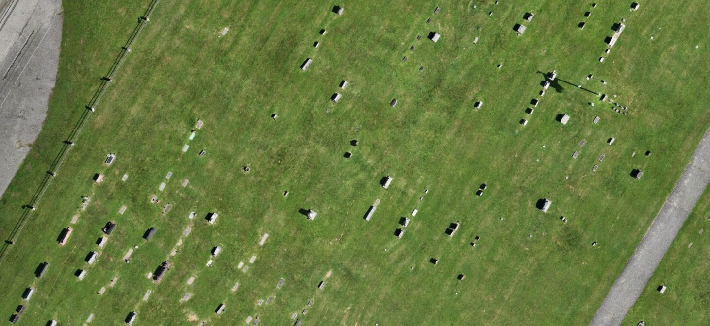
Using our drone, we can create high-resolution orthophotos that are spatially accurate and can be used in CIMS Gold and CIMS Platinum as your cemetery’s backdrop. We can also produce high-quality videos that can be used to market your cemetery and show off your beautiful grounds.
Get ProposalSave time on cemetery admin with CIMS
Explore other add-ons available with your CIMS plan.
Burial Search
Burial Search allows the public to access and navigate your cemetery’s information via the web, a smartphone, or an on-site kiosk. Compatible with CIMS Core, CIMS Plus, and CIMS Professional.
CIMS Ledger
Track sales of plots, headstones, and services, manage payments, and assign purchases to burials—directly from CIMS.
QuickBooks® Integration
Track communications across touch points and export records to Salesforce.
Salesforce Integration
Locate underground anomalies—such as unknown burial locations, hidden objects, and water or utility lines—without disturbing soil. Data captured with GPR can be integrated into your CIMS Core, CIMS Plus, or CIMS Professional software.
Ground Penetrating Radar
Locate underground anomalies—such as unknown burial locations, hidden objects, and water or utility lines—without disturbing soil. Data captured with GPR can be integrated into your CIMS Core, CIMS Plus, or CIMS Professional software.
Timeline Memorials
Build custom memorial pages for grieving families. Compatible with CIMS Core, CIMS Plus, and CIMS Professional.
Questions About CIMS?
We’re here to help you understand how CIMS can support your cemetery and the families you serve.
CIMS is a comprehensive cemetery management software designed to help cemeteries digitize records, manage grave ownership and burials, maintain accurate maps, and improve day-to-day operations.
CIMS is used by municipal, faith-based, private, and association-managed cemeteries of all sizes across the United States and Canada.
Easy-to-use inventory management features, accurate GIS mapping, multi-user capabilities, and web-based access from any device should be treated as must-haves when selecting cemetery software. Cemeteries should also consider:
Public record search capabilities, such as Burial Search.
Integration with drone imagery for mapping fidelity.
Financial tools like CIMS Ledger.
Cemetery software is an investment. 1,200+ cemeteries have invested in CIMS because our tools give your staff more time for the personal touches that matter most.
CIMS helps cemeteries move existing records, whether in analog or digital formats, into their new CIMS database. From data conversion to record entry and maintenance, the CIMS team provides a variety of data migration services to get cemeteries up and running.
Our team has helped cemeteries migrate paper records and transferred data from other tools like Microsoft Access, Microsoft Excel, Microsoft Word, Microsoft Works, CSV, DBF, and FileMaker Pro files, as well as DOS databases, and Microsoft SQL servers.
Yes. CIMS is a cloud-based platform that allows authorized users to securely access cemetery records and maps from anywhere with an internet connection.
Yes. Authorized users can concurrently access CIMS securely from multiple computers or locations.
Ready to put families first?
See how CIMS can help your team spend less time on administrative work and more time doing what truly matters—supporting families and honoring lives.